By 2100, it’s possible that 3 billion more people will live in cities than do today—meaning 357 additional New York City-equivalents will need to be constructed. The pressure to ensure this expansion doesn’t wipe out crucial biodiversity has never been greater.
An effort led by Weller to identify where these biological resources are most at risk has resulted in a tool to help navigate this new human-dominated era, the “Atlas for the End of the World.”
The Atlas, which is freely accessible online, documents land use, urbanization, biodiversity, and conservation progress worldwide. Its aim is to harness and present key data related to these areas in a visual format that governments, non-governmental organizations, urban planners, and landscape architects can use to enact better conservation and planning on the ground.
“What’s extraordinary is that over the course of the last 50 years, the conservation community has managed to protect 15 percent of the planet,” says Weller. Under the United Nation’s Convention on Biological Diversity the global target is 17 percent. To reach that figure, the equivalent of around 700,000 Central Parks will need to be protected in the next three years.
With expertise in mapping techniques and familiarity with global datasets, Weller decided to see how well the signatories were doing in reaching the goal. He began the work soon after arriving at Penn in 2013, eventually recruiting two landscape architecture students to work with him, Chieh Huang and Claire Hoch. They chose to specifically focus on ecological hotspots, areas rich with species that may be found nowhere else.
“These are parts of the world where if you lose species there, they might be gone for good,” Weller says. “For example, if we knock down a forest in Siberia or the United States, we can get that diversity elsewhere on the planet. But if you raze part of the southwestern coast of Australia or parts of South Africa, then they’re just gone forever.”
Examining the 36 recognized ecological hotspots worldwide, the team found that 21 have so far failed to meet the 17 percent conservation target. They further assessed the connections between hotspot conservation and growth of urban areas. Tracking the 423 cities of more than 300,000 people that overlap with the hotspots, Weller, Huang, and Hoch found that 383—more than 90 percent—are forecast to sprawl into high biodiversity regions, which serve as important habitats for rare and endangered species.
Though the outlook for the coexistence of people and the rest of life on Earth can seem daunting, Weller hopes that insights from the Atlas will inform planning going forward.
“This is laying the groundwork for us to move into some of these cities and get involved with more creative approaches to making future growth sustainable,” Weller says.
Eugenie Birch, co-director of Penn’s Institute for Urban Research and Lawrence C. Nussdorf Professor of Urban Education and Research in PennDesign, is president of the United Nations General Assembly of Partners, a group that represents diverse stakeholders related to urban development. She is hopeful that the Atlas will offer U.N. member states guidance in addressing the 17 Sustainable Development Goals (SDGs) established in 2015, which aim to balance economic development with environmental protection. The timing of the Atlas’s release is noteworthy, given that the U.N. Habitat-convened World Urban Forum, a major global conference on urban issues, will be held in February 2018 in Kuala Lumpur.
“What Richard has provided is really extraordinary, this interactive site that pinpoints the difficult spots, the places where we can direct global attention,” says Birch. “This is a fabulous tool for understanding how to implement the Sustainable Development Goals, especially the one called ‘Life on Land,’ that refers directly to protecting biodiversity. Some 193 nations have endorsed the SDGs, now they have the Atlas as a roadmap for action around conservation. Our most urgent task is to publicize this resource.”
In addition to a wealth of maps, the Atlas contains essays that reflect upon subjects such as how the world has changed in the 450 years since the creation of the first modern atlas, Abraham Ortelius’ Theatrum Orbis Terrarum; how new technologies have altered landscape planning and conservation; and the obstacles that contemporary conservation must navigate when it comes to protecting land while preserving the rights of indigenous people and other disadvantaged groups.
Weller had originally envisioned the project as a book, but recognized that the urgency of getting the data out meant that an online tool might be more effective.
“I’ve always valued books, not websites, but this project lent itself to a digital format and it’s been illuminating to experience the power of social media to disseminate academic information,” Weller says. “The Atlas is getting well over 1,000 unique readers every day.”
And the work is not over. With assistance from Zuzanna Drozdz, a master’s student in landscape architecture, and recent graduate Nanxi Dong, Weller is now zooming in on a few dozen of the cities located in hotspots to get a more detailed picture of whether and how biodiversity is being accounted for in urban planning.
Drozdz’s early research has revealed stark contrasts between cities.
Lagos, Nigeria, for instance, is experiencing intense population growth but is geographically limited by the waters of neighboring Lagos Lagoon and the Atlantic Ocean. Growth appears to be taking place with little regard for conserving natural areas.
“It’s to the point that they’re constructing a 10 square kilometer peninsula into the ocean,” Drozdz says. “They want to build their own Dubai, but the city’s lack of planning means that the growth is coming at the expense of people in informal developments and at the expense of biodiversity, particularly in wetland areas that continue to be degraded.”
Drozdz also notes that Lagos contains almost no greenspace. In contrast, the city government of Capetown, South Africa, has funneled considerable resources into projects that document the area’s native and endemic species. The city has also worked to integrate economic and training opportunities for low-income people into programs that target invasive species. “But even though Capetown knows the value of this biodiversity,” she says, “the disheartening thing is it’s still hard for them to get the budget to protect it.”
The power of a visual medium such as a map to inspire action, however, is compelling. The team behind the Atlas is optimistic that the project will inspire renewed commitment to making progress when it comes to sensible urban development and conservation.
“I hope that this Atlas will make people who were not aware start to care, and make people who were aware start to take action,” says Huang. “And when they do roll up their sleeves, the Atlas will hopefully be a guide to start answering their first question: ‘Okay, so where should we start?’”
Photo: Gathering information from global datasets, PennDesign’s Richard Weller and former students Chieh Huang and Claire Hoch crafted hundreds of maps to showcase the status of ecological hotspots, conservation efforts, and urban growth. This map documents proposed and in some cases partially constructed landscape connectivity projects—efforts to link fragmented ecosystems.
Nanoparticle blueprints reveal path to smarter medicines
New research involving Penn Engineering shows detailed variation in lipid nanoparticle size, shape, and internal structure, and finds that such factors correlate with how well they deliver therapeutic cargo to a particular destination.
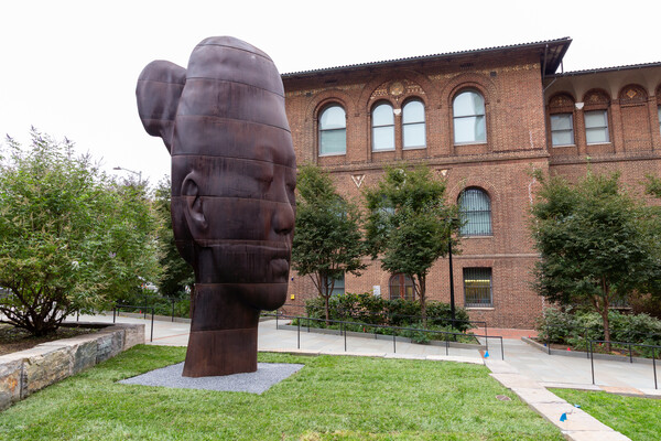
A generous gift from alumni Glenn and Amanda Fuhrman brings the work of internationally acclaimed artist Jaume Plensa to the University of Pennsylvania. The latest addition to the Penn Art Collection expands Philadelphia's public art.
A massive chunk of ice, a new laser, and new information on sea-level rise
For nearly a decade, Leigh Stearns and collaborators aimed a laser scanner system at Greenland’s Helheim Glacier. Their long-running survey reveals that Helheim’s massive calving events don’t behave the way scientists once thought, reframing how ice loss contributes to sea-level rise.