More than 250 archaeologists from around the world contributed their knowledge to ArchaeoGLOBE, an effort to better understand the prevalence of agriculture, pastoralism, and hunting and gathering at different points in human history.
To predict what will happen in the future, its important to understand what happened in the past. Thats the idea behind ArchaeoGLOBE, a project that looks at land use around the world—like in the Italian Alps, seen here—during the past 10,000 years. (Photo courtesy: Lucas Stephens)
How might the archaeological community quantify 10,000 years of land use across the world?
It’s a question Lucas Stephens pondered a great deal as a doctoral student at the University of Pennsylvania. “In environmental modeling, to predict what’s going to happen in the future you have to know what’s happened in the past,” says Stephens, who earned his Ph.D. from Penn’s Art and Archaeology of the Mediterranean World (AAMW) program in 2018 and is now at the Environmental Law & Policy Center in Chicago. “We have decent records going back to the 19th century, but not much before then.”
The information does exist, but it’s mostly siloed, well-known to the individual researchers who conduct work on particular areas but not compiled anywhere or accessible to the rest of the field.
During Stephens’ final semester at Penn, he began working with Erle Ellis, a geography and environment professor at the University of Maryland, Baltimore County, on Ellis’ Globe project, an online community for collaboration among scientists studying land change. Backed by National Science Foundation funding, the pair teamed with colleagues from University College London, the Max Planck Institute for the Science of Human History, the Smithsonian Institution, Arizona State University, and the University of Washington to create a region-based land-use survey that spanned thousands of years.
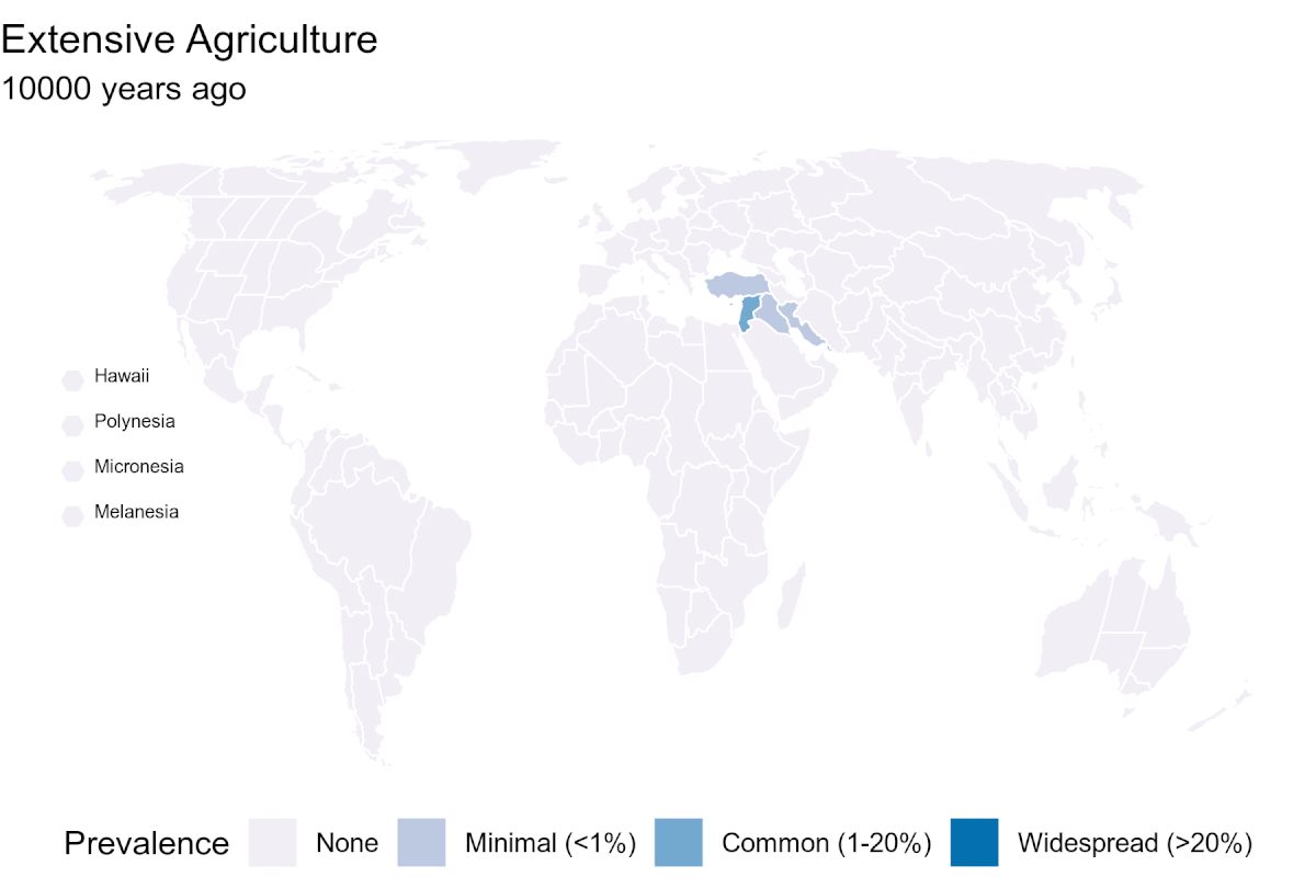
A look at how extensive agriculture—when farmers move from one field to another so the first can regenerate—at different points in human history, using data collected from archaeologists around the world.
The result was ArchaeoGLOBE, a crowdsourced database that includes more than 700 entries from 255 archaeologists around the world. For each location, researchers rated the prevalence of land-use types—agriculture, pasturing herd animals, and hunting and gathering—for 10 time periods between 1850 CE and 10,000 years ago, when modern agriculture began.
Preliminary analysis, which the researchers published in the journal Science, revealed that in South Asia and parts of Eastern Europe and Central Asia, intensive agriculture, where farmers reuse a single plot of land over and over, started thousands of years earlier than had been assumed in previous climate-modeled reconstructions of past land use. The work also points to gaps in research locales, places comparatively underrepresented in the archaeological research canon.
“This was an attempt to roughly quantify the amount of land being used across the globe for different productive uses for the past 10,000 years,” Stephens says. “This is the first time something like this has been attempted.”
Fourth-year Penn doctoral student Reed Goodman, a geoarchaeologist in the AAMW program whose work focuses on Mesopotamia in what is today Iraq, Iran, and Afghanistan, filled out the survey for four areas. “These crowdsourced conversations are a wonderful way to expand archaeological knowledge,” he says. “They’re an important new approach in a traditionally closed-off field.”
To break down some of those barriers, Stephens and colleagues sent their initial survey to 1,380 archaeologists worldwide. Scientists could contribute to as many of the 146 regions as they felt qualified to; of the 255 participants, 111 answered at least four regional surveys, noting for each of 10 time spans whether four land-use types were nonexistent, minimal, common, or widespread, as well as the absence or presence of urbanism.
An image of rice fields in Ubud, Bali, submitted by an archaeologist from the Max Planck Institute for the Science of Human History. (Photo courtesy: Lucas Stephens)
“Our four land-use types were agriculture, both intensive and extensive, pastoralism, and foraging/hunting/gathering,” Stephens says. “For our purposes, intensive agriculture is when people stay in one place and continually cultivate the same fields year after year. Extensive agriculture is when they move off from that field to a different place, so it can regenerate. Pastoralism is the use of lands for pasturing animals, most commonly sheep, goats, and cows but also llamas, yaks, reindeer, or other animals depending on the place.”
The researchers then compared the hundreds of responses to information in the most frequently used reconstruction of ancient land use, the History Database of the Global Environment, called HYDE, which is overseen by the Netherlands Environmental Assessment Agency. “In some areas, we noticed that intensive agriculture started earlier than what is commonly held to be true,” Goodman says. “That tells you how critical it is to have locally sourced empirical datasets.”
Beyond that, ArchaeoGLOBE pointed to holes in the field, what the researchers call “regional cold spots,” in places like Southeast Asia and Central and West Africa. “We do work in our own bubbles, to some extent,” says Steve Renette, a Penn lecturer, project participant, and archaeologist who conducts Early Bronze Age research in Iraq and Iran. “It’s good that these projects take us out of the bubble and help the field identify areas that are underexplored.”
As of now, there aren’t plans to continue collecting surveys on additional regions, according to Stephens. But he says he hopes what they’ve already learned can improve climate models.
“How we use land going forward, food production, how these relate to climate change—these are all crucial issues for the future of the Earth,” he says. “But we need to deepen what we know about the past to have meaningful discussions about the future. And to really understand how land was being used in the past, you have to ask the archaeologists. They’re the ones who have this knowledge, but it’s not typically in a form that’s all that usable for other scientists. This is a first big step in making it accessible.”
Funding for ArchaeoGLOBE came from the National Science Foundation (Grant CNS 1125210).
Penn physicists led by Bo Zhen have created hybrid light-matter particles that interact strongly enough to compute, pointing toward ultrafast, low-energy optical AI hardware.
Penn’s newest supercomputer is transforming research
Penn’s first campus-wide HPC and AI cluster, “Betty,” is expanding access to powerful computing, enabling groundbreaking projects, and fostering new collaborations across disciplines.
A bioengineered bean gum from the lab of Penn Dental’s Henry Daniell is found to reduce the levels of three microbes associated with head and neck squamous cell cancer to almost zero, without affecting the beneficial bacteria normally found in the mouth.
Fighting oral cancer with bioengineered chewing gum
Research led by Penn Dental’s Henry Daniell shows that antiviral and antibacterial chewing gums reduce the levels of three microbes linked to worse outcomes in oral cancers, paving the way for more effective and affordable therapies.
The performing arts at Penn: Process, practice, and purpose
In the vivid tapestry of performing arts groups at Penn, students prepare for their performances while simultaneously enriching their college experience.


