With OurPlan, Weitzman team pilots new data tool for neighborhood democracy
OurPlan gives residents of West Philadelphia a voice in planning and preservation.
What types of buildings are critical to preserving a neighborhood’s sense of itself, and what sites are ripe for change? How can residents be more informed about changes in their neighborhood and better equipped to influence its future?
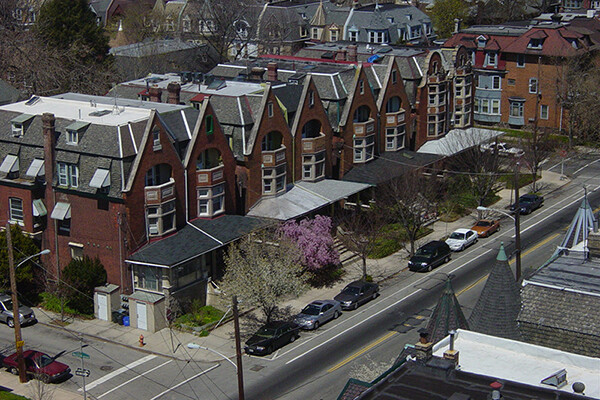
Those are the driving questions behind OurPlan, a new web-based tool for neighborhood planning developed by a team of scholars at the Stuart Weitzman School of Design. The tool, which was launched this year, combines both education and data collection to help residents participate in important planning and zoning decisions that affect their neighborhoods. Currently, the tool focuses on Spruce Hill, a West Philly neighborhood adjacent to Penn’s campus that has seen sharp increases in home prices and other indicators of gentrification over the last few decades. Users can browse a map of their neighborhood that’s linked to publicly available data on things like home sale prices, age of homes, zoning designations, and permits for alteration, demolition, and new development.
The project began in a 2019 practicum in the Master of Urban Spatial Analytics program, which was founded and led by Ken Steif, who passed away in September. The team that developed the tool included Steif; assistant professor of city and regional planning Akira Drake Rodriguez; Sydney Goldstein, a 2018 Master of City Planning graduate who was working as a data scientist at Steif’s firm, Urban Spatial LLC; Kenton Russell; and Jarvis Innovations. The tool relies on data from OpenDataPhilly for information about the built environment of Spruce Hill. Steif always envisioned OurPlan expanding to other neighborhoods, Rodriguez says, which was part of why the team chose to rely only on public data.
“It is possible to scale this to other neighborhoods in Philadelphia and that’s what we’re trying to do,” Rodriguez says. “We really want this to live, so we’re trying to get outside interests to scale it up in the way that Ken would have wanted.”
The tool includes a survey that Spruce Hill residents can complete to register their preservation preferences for the neighborhood. Using images from Google Street View, Goldstein created a feature that allows users to browse a representative sample of building types in Spruce Hill and rate how strongly they’d prefer that type of building to be preserved. It’s information that should help Registered Community Organizations (RCOs) make decisions about zoning, planning, preservation and development that are more in line with neighbors’ goals, Goldstein says.
This story is by Jared Brey. Read more at Weitzman News.
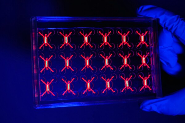
Penn engineers and collaborators have developed a transparent, micro-engineered device that houses a living, vascularized model of human lung cancer—a “tumor on a chip”—and show that the diabetes drug vildagliptin helps more CAR T cells break through the tumor’s defenses and attack it effectively.
Tumor-on-a-chip offers insight into cancer-fighting cells in immunotherapy
Penn engineers and collaborators have built a living tumor on a chip to expose how cancers block immune attacks, and how one existing drug could make immunotherapy like CAR T more effective against solid tumors.
Professor of city and regional planning Erick Guerra recently published a book exploring the economic and societal impacts of American highways. He explains some of the pitfalls associated with an ever-expansive highway system, arguing that spending more on highways might not be the solution to the country’s transportation issues.
Penn urban planner Erick Guerra’s new book, “Overbuilt,” argues that additional spending on building more highways might not be the solution to the country’s transportation issues. In a Q&A, Guerra shares his insights.
Xin Sun prepares samples collected from the Eastern Tropical North Pacific aboard a research vessel. By adding stable isotope tracers to these vials, Sun and her team can track how different microbial groups convert nitrogen compounds into nitrous oxide, revealing how subtle shifts in oxygen and organic matter change the ocean’s chemistry.
Can tiny ocean organisms offer the key to better climate modeling?
In the shadowy layers of the Pacific, microbes decide how much nitrous oxide—a potent greenhouse gas—rises skyward. New research from Penn’s Xin Sun offers an improved understanding of microbial ecology and geochemistry—key to forecasting global emissions in response to natural and man-made climate change.
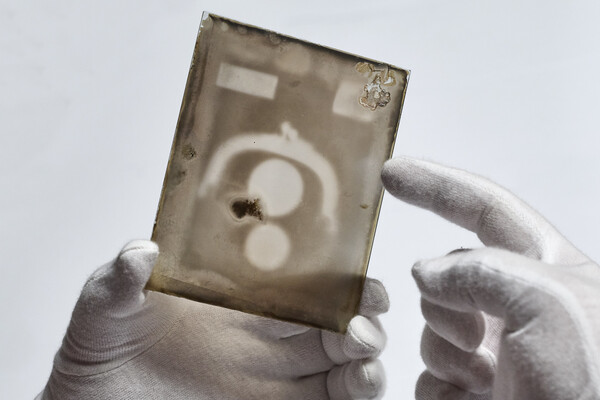
Two X-ray plates from Arthur Goodspeed, believed to have created the world’s first X-ray image, were donated by his family to Penn’s University Archives.

