Mapping smarter tree placement in Philadelphia and beyond
Weitzman School of Design graduate student Frank Chen provides insight into his project to find the best spots to plant street trees and optimize shade coverage for pedestrians in Philadelphia.
3 min. read
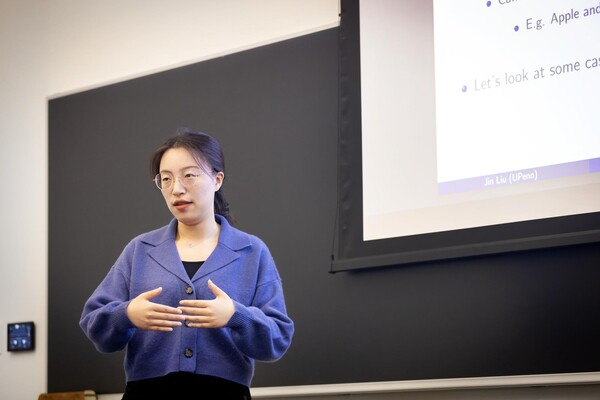
Frank Chen, a graduate student in the Weitzman School of Design, is pursuing degrees in city planning and urban spatial analytics. His research includes detecting ideal locations to plant street trees in Philadelphia, an endeavor to help reduce the impact of urban heatwaves on pedestrian health and well-being.
Long before Frank Chen was a graduate student at the Weitzman School of Design, his parents—both architects based in Hangzhou, China—shaped his profound appreciation for built environments. Throughout his youth, they took him to see landmark structures, museums, libraries, and more. While these experiences were formative, Chen developed his own fascinations with cities, maps, and urban spaces.
“I always found myself more curious about the city scale. Whenever we visited a new place, my favorite thing was to go to the bookstore or local convenience stores to get a paper map,” says Chen, pursuing degrees in Master of City Planning and Master of Urban Spatial Analytics (MUSA). “I used to study how cities were laid out, where the roads go, how things connected.”
Growing up in Hangzhou, Chen saw how fast the historic city developed, as well as the challenges this caused—from population growth and traffic congestion to limited public space. This inspired Chen, who graduated from Tianjin University with an engineering degree focused on urban and rural planning, to pursue a career in improving cities for societal benefit.
At Penn, Chen has led several projects that combine city planning with urban spatial analysis. One project—displayed at the Weitzman Year End Show—may benefit urban residents in Philadelphia and beyond.
Using cutting-edge computation tools, Chen developed a visual model that strategically maps the best places to plant street trees in Philadelphia for optimal shade and pedestrian benefit. One goal is to help address the pressing challenge of heatwaves, an emerging problem in cities worldwide.
“Heat is a public health issue and it’s causing deaths globally,” Chen says. His project involves balancing an intricate trade-off between tree shade and tree location, all with pedestrian well-being in mind.
For example, pedestrians are active in Center City Philadelphia, but tall buildings already provide shade, thereby reducing the need for street trees. Contrast that with suburban areas with shorter infrastructure, where planting trees may create more shade overall, but fewer pedestrians are around to feel the benefits.
“My work is to build a model [that] gives an optimal balanced choice between these two objectives,” Chen says, referring to the sweet spots where pedestrians benefit from street tree location and maximal shade production. “I think the city can use this project for a reference about where the trees are most needed; if we plant trees in those places, the overall benefit for the citizens is maximized.”
Data-driven research
Mentored by Weitzman faculty members Xiaojiang Li, assistant professor of urban spatial analytics, and Eric Delmelle, a lecturer in geospatial data science, Chen had a well-rounded support system to plan and execute the street tree mapping project.
Li trained Chen to code for the visual mapping component of the project using GPU computation methods. Additionally, much of Li’s published research in the fields of urban sustainability studies and geospatial data science provided Chen with substantive reference points to build upon. Delmelle, having previously taught Chen in a MUSA course, offered guidance from a spatial optimization perspective.
Both mentors also encouraged Chen to consider project limitations with an eye for urban pragmatism.
“In the data collection process, I accounted for real-world constraints—like distance to the buildings and avoiding some street poles and street intersections—so the results are practical,” Chen says.
“I think maybe one day my research can be used by the city government or some companies that can help Philadelphia residents,” Chen adds.
Improving cities for societal benefit
Chen plans to pursue a Ph.D. focused on the intersection of geography and urban planning, echoing the related paths of his parents and inspired by Penn alums Lin Huiyin and Liang Sicheng. Considered to be founding figures of modern Chinese architecture, Huiyin’s and Sicheng’s pivotal impact on the fields of architecture, city planning, and urban design motivated Chen to apply to Penn.
“I want to incorporate what I did for this tree project to develop spatial optimization tools and models—combined with other geospatial data analytics methods—to strengthen my research,” Chen says.
As city planning grows increasingly vital throughout the 21st century amid rising heatwaves and migration to urban areas, Chen is motivated to generate new solutions that help make cities safer and healthier for all.
“Projects that have real-world implications are really exciting for me,” Chen says. “You know it has the potential to help people, and that’s the most rewarding feeling.”
Nanoparticle blueprints reveal path to smarter medicines
New research involving Penn Engineering shows detailed variation in lipid nanoparticle size, shape, and internal structure, and finds that such factors correlate with how well they deliver therapeutic cargo to a particular destination.
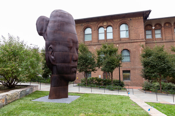
A generous gift from alumni Glenn and Amanda Fuhrman brings the work of internationally acclaimed artist Jaume Plensa to the University of Pennsylvania. The latest addition to the Penn Art Collection expands Philadelphia's public art.
A massive chunk of ice, a new laser, and new information on sea-level rise
For nearly a decade, Leigh Stearns and collaborators aimed a laser scanner system at Greenland’s Helheim Glacier. Their long-running survey reveals that Helheim’s massive calving events don’t behave the way scientists once thought, reframing how ice loss contributes to sea-level rise.